Valldalsleden
Valldal - Lesja - Dovrefjell
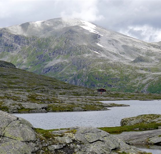
Difficulty: Medium, Demanding
Type of terrain: Forest trails, gravel roads, mountains. Steady ascent from start to finish.
Valldalsleden runs from Sylte in Norddal municipality, up Valldalen to Grønningseter, through Reinheimen National Park, further down through Lesja and into Dombås. From here the trail goes up to Fokstugu on Dovrefjell where it connects to Gudbrandsdalsleden. Valldalsleden offers varied terrain, with multiple kinds of accommodation and is considered demanding. This is both due to the slope and terrain, but also because it is necessary to carry some food and equipment. You must also be comfortable using a map and compass and/or GPS equipment. In the high mountains, you also have to expect to go several days without mobile coverage.
This path was Olav's escape route in the winter of 1028 - 1029. He landed his ship in Valldal and went over the mountain to Lesja and Dovre. The journey is described in Snorri's "Saga of St. Olaf" which you can find in Heimskringla.
It is a scenic trail with everything from fjord landscapes to steep gorges and mountain terrain. It can be walked in about a week, but it is also well suited for those who want to take their time, who want to reflect on the many impressions that come forth on the hike.
Don't walk too early in the summer: Although the main season for pilgrimage in Norway in general is 1st June - 1st September, the season is much shorter on the Valldalsleden trail because it goes through high mountains. Often the trail is not passable until well into July, so you should find out how the situation is this in this years season before starting your trip. You can get information about the current situation from the Fjordhagen office in Valldal, contact Gro Marita Stennes Valdal by phone +47 969 00 904, or email, GroMarita@fjordhagen.com
****
There are enough shelters/cabins along the way, but plan and prepare well. It is not necessary with a tent, but of course, it depends on how long you want to walk per day. Be aware that the daily hiking stages here are much shorter than on more lowland trails, due to the large amount of rock and gravel, as well as the steep terrain.
9 suggested daily stages:
1. Valldal-Alstad 16,5 km
2. Alstad-Tjønnebu 12,8 km
3. Tjønnebu-Vakkerstøylen 15,9 km
4. Vakkerstøylen-Rånå 22,1
5. Rånå-Lesjaskog 16,5 km
6. Lesjaskog-Lesjaverk 16,2 km
7. Lesjaverk-Lesja 29,3 km
8. Lesja-Dombås 16,8 km
9. Dombås-Fokstugu 10 km
There are two grocery stores in the centre of Valldal, before you start hiking. If you book accommodation at Juvet landskapshotell or Gudbrandsjuvet camping (between stage 1-2), there is also possibilities for eating there before you continue. You can also buy tin-can food at the DNT cabin Vakkerstøylen https://ut.no/hytte/10549/vakkerstylen (but not in the DNT cabin Tjønnebu). The next possibility to buy food is in Bjorli, the grocery store is 3km from the pilegrim route (between stage 4 and 5). If you chose not to stop in Bjorli, the next grocery store is in Lesjaskog between stage 5 and 6.
Read more about the trail here, where you also find a link to our digital planning tool and map with all information about accomodations etc: Pilegrimsleden | Valldalsleden
In general:
If you are new with pilgrimage, may be a part of Gudbrandsdalsleden is better for you? Dovrefjell and further to Trondheim is beautiful as well, and you will meet other pilgrims. Valldalsleden is not recommended if this is your first pilgrimage. For Valldalsleden, you need to be experienced with trekking in high mountain terrain.
Experiences along this route
-
Church
Sylte church
Valldalsleden -
Cultural Heritage
St. Olav's Cross at Korsbrekka
Valldalsleden -
Church
Lesja Church
Valldalsleden -
Cultural Heritage
The serpent in Syltefjellet
Valldalsleden -
Accommodation
Gudbrandsjuvet camping
Valldalsleden -
Accommodation
Juvet landskapshotell
Valldalsleden -
Accommodation
Valldal Fjord Lodge
Valldalsleden -
Accommodation
Valldal Fjord Hotel
Valldalsleden -
Cultural Heritage
Døving Chapel
Valldalsleden -
Accommodation
Muri hytteutleige - cabin rental
Valldalsleden -
Accommodation
Sylte Hotel
Valldalsleden -
Cultural Heritage
Krossbrekke
Valldalsleden -
Accommodation
Meretes Garden
Valldalsleden -
Cultural Heritage
Skjervsura
Valldalsleden -
Cultural Heritage
Olav's spring and Olav's cave
Valldalsleden -
Cultural Heritage
Grønningene summer farm
Valldalsleden -
Accommodation
Tjønnebu
Valldalsleden -
Accommodation
Vakkerstøylen
Valldalsleden -
Accommodation
Koia - Cabin in Verma
Valldalsleden -
Accommodation
Bjorliheimen hotel
Valldalsleden -
Accommodation
Trolltun Hotell og Hytter
Valldalsleden -
Accommodation
Dombås gard
Valldalsleden -
Accommodation
Dombås Hotel
Valldalsleden -
Accommodation
Midtskog camping
Valldalsleden -
Accommodation
Lesja Guesthouse
Valldalsleden -
Accommodation
Kolstad farm
Valldalsleden -
Accommodation
Tynnøl Backpackers Lodge
Valldalsleden -
Accommodation
Lorkverna
Valldalsleden -
Accommodation
Kvennbekkhytta
Valldalsleden -
Accommodation
Aaheim camping
Valldalsleden -
Accommodation
Lesjaskogsvatnet camping
Valldalsleden -
Accommodation
Gammelstuggu
Valldalsleden -
Accommodation
Sør-Einbu
Valldalsleden -
Church
Lesjaskog Church
Valldalsleden -
Church
Lesjaverk Church
Valldalsleden -
Church
Dombås Church
Valldalsleden, Gudbrandsdalsleden -
Food store
Bunnpris Lesjaskog
Valldalsleden -
Food store
Coop Marked Lesjaverk
Valldalsleden -
Food store
Joker Lesja
Valldalsleden -
Food store
Dombås sentrum
Valldalsleden -
Accommodation
Ljoshaugen camping
Valldalsleden, Gudbrandsdalsleden -
Cultural Heritage
Einbu monument
Valldalsleden -
Transport
Dombås stasjon
Gudbrandsdalsleden, Valldalsleden -
Accommodation
Fokstugu Mountain Lodge
Gudbrandsdalsleden
Useful reading